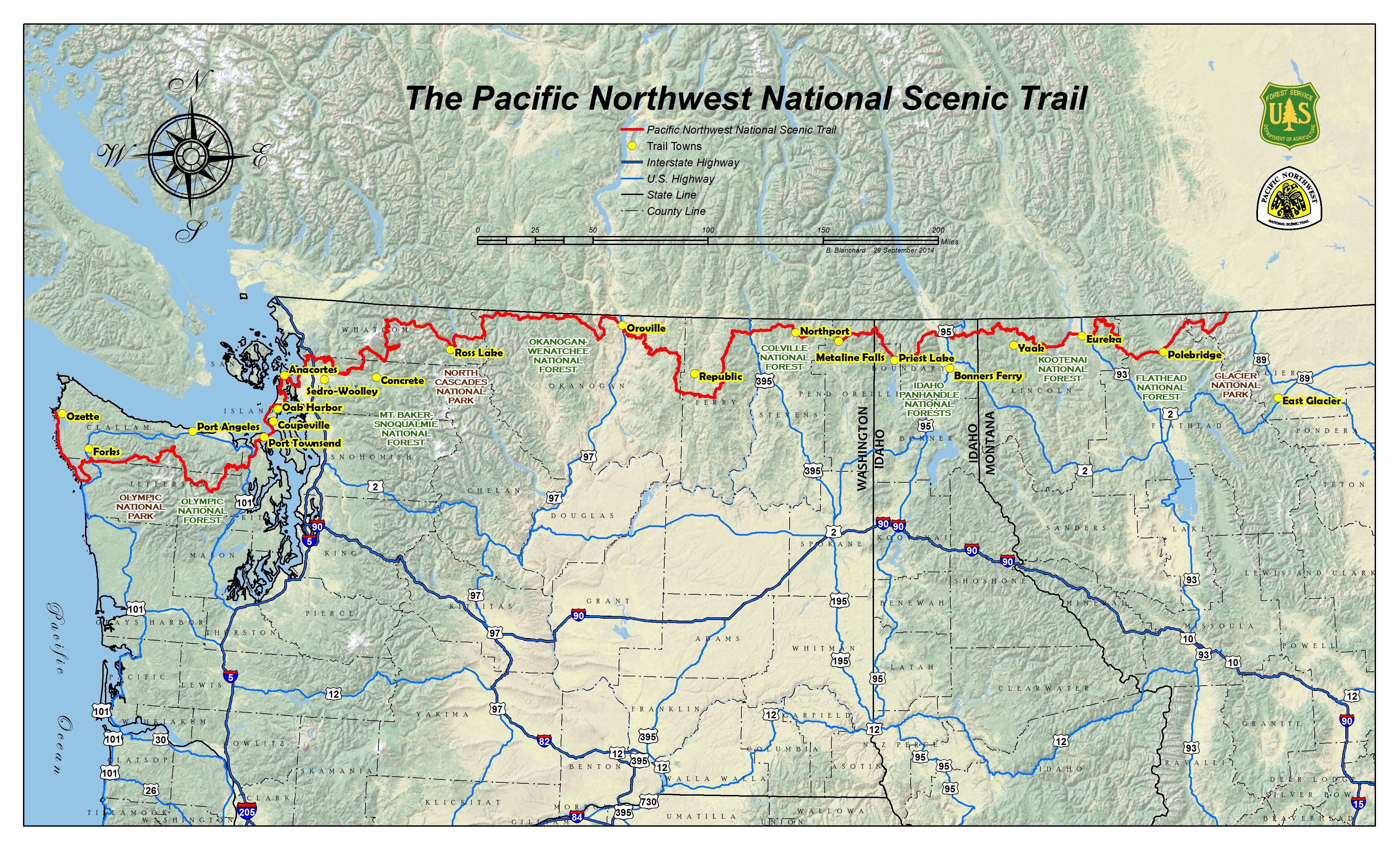
Trail
Maps

Navigation Can Be Challenging On the PNT

Carrying multiple navigation tools and having the knowledge to use them is essential on the Pacific Northwest Trail. While some popular areas along PNT can be relatively straightforward to follow, most of the trail way is an unsigned and unmarked. Even experienced thru-hikers can find it challenging to navigate compared to longer established national scenic trails. We recommend learning more about the PNT and checking trail conditions before you set out for the trailhead.

These large scale Overview Maps are designed to be used with PNTA Strip Maps to aid in trip planning. Use these maps to explore the trail before you go and to “choose your adventure” from the many popular alternate routes along the 1200 mile trail corridor. The PNTA map set also describes the PNT as 50 consecutive stages to make it simpler to compare mileage and other characteristics of various routes.

This download includes an 140 page set of annually revised Strip Maps designed for trail navigation. It also includes a set of section Overview Maps, a resupply planner, permit guides, and other supplemental maps and info, including a land acknowledgement map. All official and popular alternate routes are included as well as detailed page notes which describe trail conditions and promote responsible trail use, Leave No Trace Outdoor Ethics and land manager regulations.

2024 map sets — Pre-order a set of maps today and receive your order in early May.  This bundled offer includes one annual PNTA membership with and a set of patches and stickers. The map set includes one 155-page set of PNTA strip maps printed on premium, water-resistant paper, a 16-page set of section overview maps, and other trip planning resources.

Companion Resources

Using multiple navigation tools is essential on the Pacific Northwest Trail. PNTA maps are designed to be used with companion resources, like The Pacific Northwest Trail Digest, an essential tool for every aspiring thru-hiker. While critical notes are included on the PNTA Strip Maps, guidebook author, Tim Youngbluth provides supplemental information to help in navigation, route choice decisions, resupply and much more.


The FarOut Guide to the Pacific Northwest Trail (formerly Guthook Guides) is a map-based hiking app that can turn your smartphone into a powerful navigation tool. The official hiking app of the Pacific Northwest Trail Association is produced through a partnership with FarOut Guides to deliver the most up-to-date information about our dynamic trail corridor.

Maps of the Pacific Northwest Trail in our National Parks

National Geographic Maps

National Geographic Trail Illustrated Maps can be extremely useful for navigating the PNT on our National Parks and adjacent National Forests. These large scale maps can supplement your navigation toolset with trail and topographic information for a much a larger area around the PNT trail corridor than our PNTA strip maps show. Please note that these maps may not show popular alternate routes of the PNT.

NPS Backcountry Trip Planning Maps

The National Park Service provides maps of the backcountry campsites found along the PNT in Glacier, North Cascades and Olympic National Park. These maps can be very useful in planning a backcountry permit.

Learn more on our Backcountry Permits webpage. 

Maps of the PNT on our National Forests

Maps of the PNT on our National Forests can be found at the links below. Please note that the Pacific Northwest National Scenic Trail may not be called out on these maps. In some cases, the trail corridor may only be referred to by a local trail name (i.e. Kettle Crest Trail #13).

Maps of the PNT on other Public Lands

Maps of the Pacific Northwest Trail on state, county, and municipal lands can be found at the links below. Please note that the congressional route or popular alternate routes of the PNT may not be indicated on these trail maps. In some cases, the trail corridor may only be referred to by a local trail name.

FAQ About Navigating the PNT

Menu